Prairie soil moisture levels and need to scout for apothecia of the sclerotinia stem rot pathogen, June 19, 2023
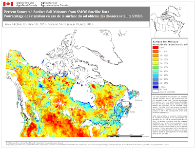
As of June 19, the need to scout fields for apothecia of the stem rot fungus and/or to assess in-field risk is low. This is based on soil moisture maps (Figures 1-3) and that flowering in most canola crops is still two or more weeks away. However, recent rainfall over some Prairie regions will likely trigger the start of the sclerotial germination process, which can take up to three weeks. Further rainfall and crop canopy closure may increase the risk of sclerotial germination and apothecia production. Further soil moisture map updates will help to identify regions where soil moisture conditions are conducive for sclerotial germination. In these areas in-crop scouting and the use of available stem rot risk assessment tools may be needed as part of fungicide use decisions (https://www.canolacouncil.org/canola-encyclopedia/diseases/sclerotinia-stem-rot/#forecasting-and-risk-assessment).
Background information on the soil moisture maps can be found at the following link: New for 2023: Prairie Soil Moisture Maps.
Figure 1. Percentage of normal soil moisture (drought model) as of June 19, 2023. Courtesy of Agriculture and Agri-Food Canada’s Science and Technology Branch, AAFC Geomatics.
Figure 2. Percent saturated surface soil moisture from SMOS satellite data, June 12-18, 2023. Courtesy of Agriculture and Agri-Food Canada’s Science and Technology Branch, AAFC Geomatics.
Figure 3. Difference from long term average, percent saturated surface soil moisture from the Soil Moisture and Ocean Salinity (SMOS) data, June 12-18, 2023. Courtesy of Agriculture and Agri-Food Canada’s Agroclimate Geomatics and Earth Observation Division.
Disclaimer
Information related to soil moisture is OFFERED TO THE PUBLIC FOR INFORMATIONAL PURPOSES ONLY. Agriculture and Agri-Food Canada, and their employees assume no liability from the use of this information. Soil moisture conditions will vary depending on soil texture, and localized rainfall and temperature conditions. Sclerotinia stem rot risk will vary depending on host, pathogen and weather factors, and farmers and consultants are encouraged to use currently available risk assessment tools (https://www.canolacouncil.org/canola-encyclopedia/diseases/sclerotinia-stem-rot/#forecasting-and-risk-assessment).


